Senegal Maps
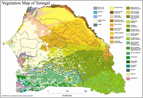
The above map shows the vegetation in the country. In north Senegal you will see desert like land. In the west of the coast you see more agriculture ready land. The south east you will see woodlands. This countries land vegetation is pretty diverse.
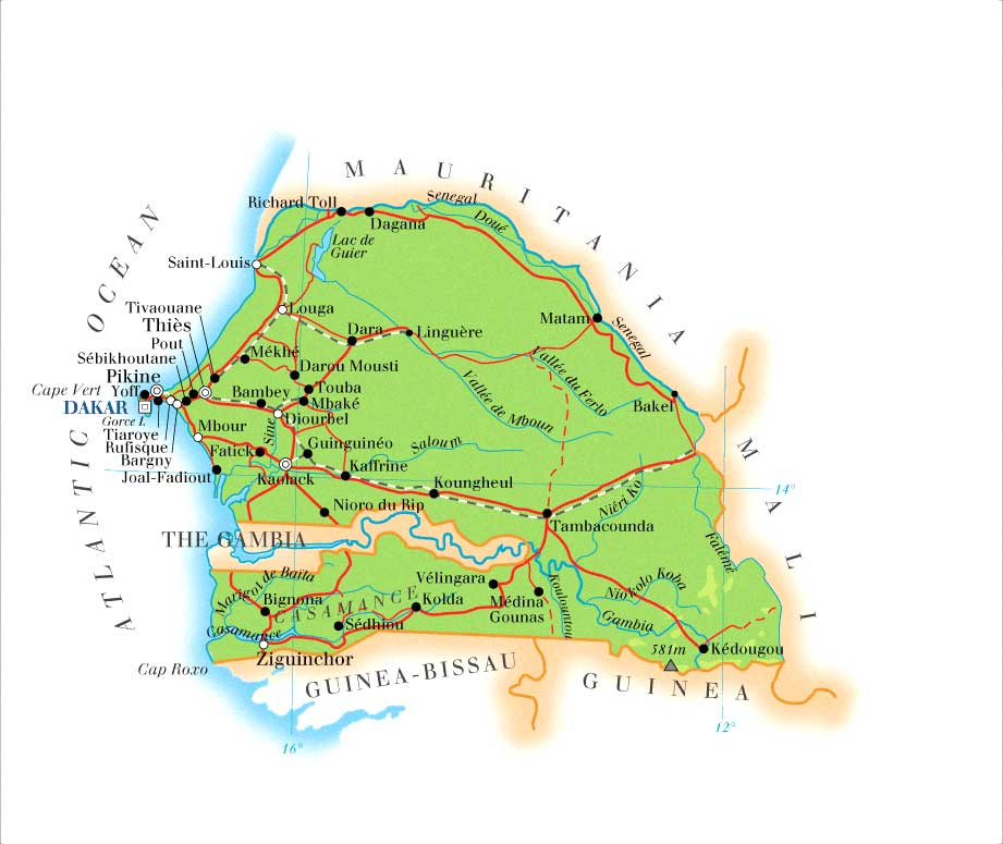
Above is a detailed map of Senegal. You will see cities, roads, lakes, and the Senegal river.
|
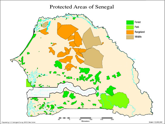
Above you will see a map of the protected areas of Senegal. These area are parks, forest, rangeland, and areas for wildlife.
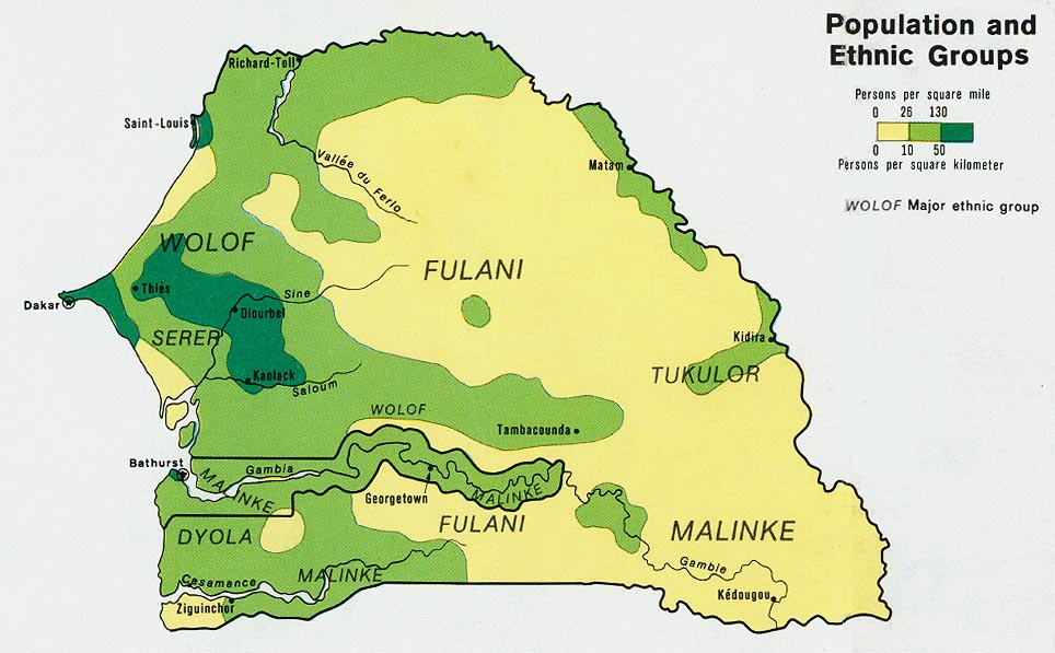
Here is a map of the population of areas with predominately certain ethnic groups. The land that is dark green represents the area with the abundant amount of people. The Fulani people are predominately more east but there are not a lot of people. Fulani people are known to be nomadic people who raise cattle.
|
People, Cities and Landscapes
|
In this slide show, you will see the diversity in landscapes in Senegal. Also, you will see an aerial view of the coastal capital of Dakar and the island of Saint Louis, which was the former capital. You will also see the green range lands, the Ferlo desert in north Senegal, the beaches in Dakar, and Lac Rose which is the pink lake.
|
In this slideshow you will see the diversity in people and cultures in Senegal. The different ethnic groups in Senegal are: Wolof, Fulani, Serer, Jola, Mandingo, Soninke, Lebanese, Chinese, European/other.
There are well built cities and there are rural area villages. You will see the tallest statue on the continent of African. It is the African Renaissance statue in Dakar. You will see the Door of No Return, which is the infamous site the captured Africans were kept before put in the ships to be slaves in the Americas. |
Connection between biodiversity and cultural identity in Senegal
| biodiversity_senegal.docx |
References
(2015). Retrieved from http://www.ciee.org/study-abroad/images/programs/0108/headers/desktop/dakar-senegal-summer-study-language-senegalese.jpg
(2015). Retrieved from http://www.cirad.fr/var/cirad/storage/images/media/import-dossiers/images-et-fichiers-resultats-2014/es-toure-fig-1/95913-2-fre-FR/es-toure-fig-1_lightbox.jpg
(2015). Retrieved from http://www.senegalvision.com/galerie/data/553/saison-pluie-senegal-oriental.jpg
chinese culture day in Dakar. (2015). Retrieved from http://img3.vtibet.com/en/news_1746/world/201404/W020140429428950168401_r75.jpg
Chinese vendor in Senegal. (2015). Retrieved from http://blog.goethe.de/weltstadt/uploads/NziNarcis_01_600.jpg
dakar beach. (2015). Retrieved from http://helenscales.com/wp-content/uploads/2012/05/mini-beach-7.jpg
Dakar City. (2015). Retrieved from http://www.summer.harvard.edu/sites/2015.summer.harvard.edu/files/imagecache/stab_slide/sites/2014.summer.harvard.edu/files/dakar_2015_04_0.jpg
ferlo. (2015). Retrieved from http://www.noveltis.com/desurvey/images/Ferlo_fig3.jpg
Ferlo Desert. (2015). Retrieved from http://i48.tinypic.com/2lsyyrb.jpg
Ferlo Desert. (2015). Retrieved from http://www.cirad.fr/var/cirad/storage/images/media/import-dossiers/images-et-fichiers-resultats-2014/es-toure-fig-3/95915-2-fre-FR/es-toure-fig-3_lightbox.jpg
Fulani women. (2015). Retrieved from https://pbs.twimg.com/media/CAzupvUU0AAiLDd.jpg
Goree: Senegal's slave Island. (2015). Retrieved from http://ichef.bbci.co.uk/news/624/media/images/68410000/jpg/_68410145_68409831.jpg
Lac Rose. (2015). Retrieved from http://www.discoversenegal.com/da/cultya.html
Lca.usgs.gov MAP GALLERY,. (2013). Land Cover Applications and Global Change. Retrieved 17 July 2015, from http://lca.usgs.gov/lca/biodiversity_senegal/mapgallery.php
Lebanese Children in West Africa. (2015). Retrieved from http://www.menassat.com/files/images/Lebanon,%20Children%20of%20Domestics.jpg
MALI empire map circa 1,350 C.E. (2015). Retrieved from https://upload.wikimedia.org/wikipedia/commons/8/8f/MALI_empire_map.PNG
Population and Ethnic groups. (2015). Retrieved from http://scholars.indstate.edu/bitstream/10484/1536/1/Housley,%20Kasandra.PDF
Saint Louis, Senegal. (2015). Retrieved from http://www.preventionweb.net/applications/hfa/lgsat/en/image/href/463
senegal detail. (2015). Retrieved from http://www.ohada.com/content/pays/cartes/senegal_detail_3.jpg
Senegal's African Renaissance Monument. (2015). Retrieved from http://40.media.tumblr.com/21fbf75e56a4c8622aefc2ecceddc5ad/tumblr_mt1hn8YrW71r1thfzo4_1280.jpg
Wolof women in Goree Island. (2015). Retrieved from https://jangawolof.files.wordpress.com/2007/11/goreeislandgroupandyoungdru.jpg
World Atlas Senegal. (2015). Retrieved from http://www.worldatlas.com/img/areamap/0dadf3332d10aea28eeddddaa2db4b5f.gif
